
உள்ளடக்கத்திற்குச் செல்லவும்
இப்போது

தொடர்கிறதுநாள் 6

The Port-Olry earthquake

  1. புதுப்பிப்பு 2 / 2சமீபத்தியதுநாள் 64 நாட்கள் கழித்து

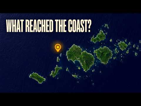
    Vanuatu quake’s low-impact forecast leaves local damage and coastal guidance unclear

    Initial assessments point to low humanitarian impact after the October 24 offshore earthquake, but local damage and current coastal-safety guidance remain unconfirmed.
    பாருங்கள்

    The Watchers

    • EarthquakeTracker lists a magnitude-5.1 mww earthquake 203 kilometres northwest of Port-Olry.
    • A separate listing places a magnitude-4.5 mb earthquake 195 kilometres northwest of Port-Olry.
    • The reviewed magnitude-6.3 mb earthquake strikes 170 kilometres northwest of Port-Olry.
    • EarthquakeTracker lists a magnitude-5.1 mb earthquake 170 kilometres northwest of Port-Olry.
    • A magnitude-5.2 mb earthquake is listed 202 kilometres northwest of Port-Olry.
  2. புதுப்பிப்பு 1 / 2நாள் 1

    Magnitude 6.3 quake strikes offshore Vanuatu; impacts still unclear

    The reviewed quake struck 204 kilometres west-northwest of Port-Olry. Early catalog entries establish neither a tsunami warning nor an all-clear on damage.

    பாருங்கள்

    USGS

    • 6.3Reviewed earthquake magnitude
    • 10 kmRecorded depth
    • 204 kmWest-northwest of Port-Olry

யார் வெளியிட்டனர்

யார் வெளியிட்டனர்

34 ஊடகங்கள் · 86 ஆதாரங்கள்

இந்த நேரத்திற்குள் 34 ஊடகங்களில் 8 செய்தி வெளியிட்டிருந்தன

யார் என்ன செய்தி வெளியிட்டனர்

ஒன்றுக்கு மேற்பட்ட ஊடகங்கள் வெளியிட்ட அம்சங்கள்

ஒரே ஊடகம் மட்டும் வெளியிட்ட அம்சங்கள்10

USGS மட்டுமே வெளியிட்டது

GDACS மட்டுமே வெளியிட்டது

Latest news from Azerbaijan மட்டுமே வெளியிட்டது

ஒவ்வொரு வரியும் அந்த ஊடகத்தின் செய்தியிலிருந்து நாங்கள் பதிவு செய்த கூற்று. நிலவரப்படி ஒப்பிடப்பட்டது.

காலவரிசை

காலவரிசை

நாள் 6 · 2 அறிக்கைகள்

  1. முதலில் வெளியிட்டது

  2. 4 நாட்கள் பிறகு

  3. EarthquakeTracker lists a magnitude-5.1 mww earthquake 203 kilometres northwest of Port-Olry.

  4. A separate listing places a magnitude-4.5 mb earthquake 195 kilometres northwest of Port-Olry.

  5. The reviewed magnitude-6.3 mb earthquake strikes 170 kilometres northwest of Port-Olry.

  6. EarthquakeTracker lists a magnitude-5.1 mb earthquake 170 kilometres northwest of Port-Olry.

  7. A magnitude-5.2 mb earthquake is listed 202 kilometres northwest of Port-Olry.

வரலாறு

  1. தொடங்கியது1 அறிக்கை

  2. The October 24 Port-Olry earthquake ஐ உள்ளடக்கியது1 அறிக்கை

    Both charters describe the same October 20, 2026 Port-Olry earthquake, with matching magnitude and location; the October 24 Port-Olry quake is explicitly excluded and is a separate event.

யார் சம்பந்தப்பட்டுள்ளனர்

யார் சம்பந்தப்பட்டுள்ளனர்

அமைப்புகள்

  • United States Geological Surveyscientific agency of the United States government

இடங்கள்

  • Port Olry
  • Vanuatu

தொடர்புடைய செய்திகள்

தொடர்புடைய செய்திகள்

  1. அதே நிகழ்வுVanuatu tsunami warning lifted after magnitude 6.9 quake and repeated shocks
Vanuatu quake’s low-impact forecast leaves local damage and coastal guidance unclear