灾害 · 瓦努阿图地震
瓦努阿图地震影响预测较低,但当地损失和沿海安全指引仍不明朗
10月24日海域地震的初步评估显示,人道主义影响较低,但当地损失情况和当前沿海安全指引仍未得到确认。
原语言视频
文字实录 · 正在加载
译自英文原文。
新闻追踪第 5 天
1 篇报道13 家媒体25 个来源
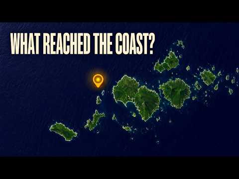
瓦努阿图北部海域地震的初步评估显示,人道主义影响较低。但目前还无法据此判断是否有人受伤、房屋受损或基本服务中断。估计有4,000人位于烈度IV震感区内;这一区别,决定了我们得到的是令人安心的预测,还是对实际情况的描述。1 21
经复核的6.3 mb级地震于2026年10月24日瓦努阿图时间下午1:35:57(UTC时间02:35:57)发生,震中位于Port-Olry西北170公里处。记录显示震源深度为10公里。全球灾害预警与协调系统(GDACS)对震级、深度和发生时间(精确到分钟)予以印证。1 21
另一个重要的不确定因素是沿海安全。地震目录标注“无海啸”,而GDACS在两个波浪字段中均列出6厘米的数值。这两条记录都不能确定沿海社区当前应遵循的指示,瓦努阿图国家当局针对这次事件发布的指引也尚未得到核实。1 21 6
令人安心的评估究竟意味着什么
美国地质调查局的记录将此次地震评为绿色PAGER警报。GDACS根据震级、人口暴露情况和脆弱性,评估其潜在人道主义影响较低,并给出0分。这些是对预期后果的评估,并非经确认的伤亡人数或建筑物受损统计。该评估中的0分,并不代表报告称损失为零。1 21
同样,估计约有4,000人暴露于修订麦加利烈度IV级的震感,也不意味着4,000人受伤、流离失所或需要援助。这一数字描述的是估计位于某一震感区域内的人口。仍需当地社区的报告,才能确定实际后果。21
地震震级和震感烈度回答的是不同问题。经复核的震级为6.3 mb:字母表示体波震级,其依据是在地球内部传播的地震波测定。不能不加说明地将其重新标为矩震级。事件记录中的最大估计烈度为修订麦加利烈度4.458,描述的是某一地点的震感,而非地震本身的规模。1
这些区别很重要,因为详尽的地震记录看起来可能比实际更为确定。精确的发震时间和估计的震感范围可以确定震动发生的地点和时间,却不能证明某座建筑、某条道路或某项通信服务是否完好无损。
目录标记不等于安全指引
海啸信息也需要同样谨慎解读。GDACS在“最大波浪预警”和“最大实时波浪”两个字段中均列出0.06米,即6厘米。目前尚未确定该数值对应的测站、沿海地点或观测记录。尽管字段名称如此,也不能负责任地将其描述为某一特定海岸实际测得的波浪。21
其存在也不一定与美国地质调查局(USGS)目录中的“无海啸”标记相矛盾。该标记在实际操作中的确切含义,以及GDACS波浪数值的来源,仍未厘清。在没有这些定义的情况下,不能把两条记录视为对沿海居民最需要了解的问题——“现在应遵循什么指示?”——给出的相互竞争的答案。1 21
《The Watchers》在10月24日关于更大范围地震序列的报道中称,太平洋海啸预警中心于UTC时间03:28表示海啸威胁已经过去。但相关原始公报及其是否适用于这次特定地震尚未得到核实。瓦努阿图气象与地质灾害局(VMGD)或国家灾害管理办公室针对这次事件发布的指示或解除警报,也均未得到核实。11 6
VMGD的地震列表标注日期为10月24日,但该列表并未确定公告发布时间,也没有说明当前沿海地区应遵循的指示。另有报道涉及10月20日地震后的安全问题,针对的是更早发生的事件,不能作为10月24日解除警报的依据。6 24 25
多次震动,一个尚未厘清的序列
这次6.3级地震与另外四次分别列出的附近地震相邻。EarthquakeTracker的列表将这些地震的测定结果归于经USGS复核的记录,但无法获得这些周边事件的独立一手确认。它们各自不同的标识符和发震时间,表明它们并非同一地震的重复报道或更新。四次地震记录的震源深度均为10公里。5 9 8 7
附近地震,按UTC时间
- 10月23日,22:05:10 UTC5
EarthquakeTracker列出了一次5.1 mww级地震,震中位于Port-Olry西北203公里处。
- 10月24日,00:27:44 UTC9
另一条记录列出了一次4.5 mb级地震,震中位于Port-Olry西北195公里处。
- 10月24日,02:35:57 UTC1
经复核的6.3 mb级地震发生在Port-Olry西北170公里处。
- 10月24日,03:08:45 UTC8
EarthquakeTracker列出了一次5.1 mb级地震,震中位于Port-Olry西北170公里处。
- 10月24日,03:17:55 UTC7
一条记录列出了一次5.2 mb级地震,震中位于Port-Olry西北202公里处。
这些地震之间的官方关系尚未确定。将较早的震动称为前震,或将较晚的称为余震,都超出了已核实的分类范围。附在6.3级地震记录中的另一项UTC时间06:36,是记录更新的时间,并非又发生了一次地震。6 13
播出原貌 16 行
- A magnitude-six-point-three earthquake struck offshore from northern Vanuatu.
- About four thousand people are estimated to have been within an area of level-four shaking. The unresolved questions are the damage on land and the current safety guidance for coastal communities.
- The earthquake struck one hundred seventy kilometres northwest of Port-Olry, at a listed depth of ten kilometres. It happened on October twenty-fourth, twenty twenty-six, at about one thirty-five in the afternoon, local time.
- The reviewed magnitude is six point three on the body-wave scale, which uses seismic waves travelling through the Earth. The measurement is labelled m b. That label belongs with the magnitude when comparing this earthquake with others.
- About four thousand people fall within the estimated level-four shaking area. That gives the earthquake a human scale beyond its offshore location. The estimate counts people exposed to shaking; their actual circumstances still depend on what happened in their communities.
- Shaking intensity describes conditions at a particular location. The maximum estimated intensity is four point four five eight on the Modified Mercalli scale. Magnitude describes the earthquake itself, while intensity helps describe how its shaking reaches different places.
- The initial humanitarian assessment is low, with a score of zero. The earthquake also carries a green alert for expected impacts. Those assessments consider the earthquake's magnitude, the population exposed and people's vulnerability. They estimate consequences before local conditions are fully known.
- We still don't know whether anyone was hurt, or whether buildings and essential services were damaged. The low-impact assessment offers some reassurance, but communities' experiences are the information needed to understand the actual consequences.
- Port-Olry is the reference point for locating the offshore shock. For coastal communities, the practical concerns extend beyond shaking to tsunami instructions. The earthquake catalog and the disaster assessment contain different kinds of tsunami information, and each needs careful interpretation.
- Four other nearby earthquakes surround the six-point-three in time. They're listed as separate events, each with its own origin time and identifier. All four have listed depths of ten kilometres. Their official relationship to the six-point-three hasn't been determined.
- A magnitude-five-point-one shock and a four-point-five came before the six-point-three. A five-point-one and a five-point-two followed it. These are nearby shocks. Calling them aftershocks or foreshocks would require an official assessment of how the earthquakes relate to one another.
- A later update time attached to the six-point-three describes a change to its earthquake listing. The earthquake's origin time stays the same. A separate uncertainty concerns a larger magnitude mentioned in descriptions of the wider sequence.
- A magnitude-six-point-nine earthquake reportedly struck shortly before the six-point-three. Another sequence tally puts six-point-three highest in its reporting period. Different time windows, distinct earthquakes or a magnitude revision could explain the difference, but the larger event's identity remains unresolved.
- The tsunami catalog flag reads no. The disaster assessment also lists six centimetres in both its maximum-wave-alert and maximum-wave-realtime fields. We don't know whether that value came from a model or an observation, or which coast it might describe.
- A tsunami-threat-passed bulletin has also been reported for the wider sequence. Its application to this earthquake hasn't been confirmed. The catalog flag and the six-centimetre entry can't settle what instructions currently apply to people along the coast.
- Current event-specific instructions from Vanuatu's Meteorology and Geo-Hazards Department or National Disaster Management Office remain unclear. Safety statements about an October twentieth earthquake concern that earlier event. For October twenty-fourth, the humanitarian outlook is low, while conditions in affected communities and current coastal guidance still need confirmation.
来源
25 个来源13 家媒体
The Watcherswatchers.news2
Faultlineduskengineering.services1
inquirer.net1
iris.edu1
PMN | Pacific Media Networkpmn.co.nz1
SeismoWatchseismowatch.com1
UA.NEWSua.news1
vmgd.gov.vu1
来源地图
追溯本篇报道的依据。图谱展示其关联;下方链接可打开本文引用的来源。
来源图谱将在您阅读时加载。
译文更新于
修订记录
- r1首次发布。