
Conflict · flood emergencyContinuing story · report 1 of 5
Indiana's White River Tops 1913 Record as Floods Force Statewide Emergency
More than 11 inches of rain pushed the White River past its 1913 record, forced evacuations, and left at least seven dead — with some broadcast details still unverified.
Transcript · LOADING
Continuing storyDay 1
5 reports22 outlets42 sources5 videos
Full story- No dated events yet
 Update 1Indiana's White River Tops 1913 Record as Floods Force Statewide EmergencyYou are here
 Update 2White River Tops 1913 Record as Indiana Floods Kill at Least SevenNewer
 Update 37 Dead as Indiana Declares Disaster Emergency in Historic August FloodNewer
 Update 4Seven Dead as White River Sets Record Crest in Central Indiana FloodsNewer
 Update 57 Dead in Indiana as White River Hits Record Crest After Six Days of StormsNewer
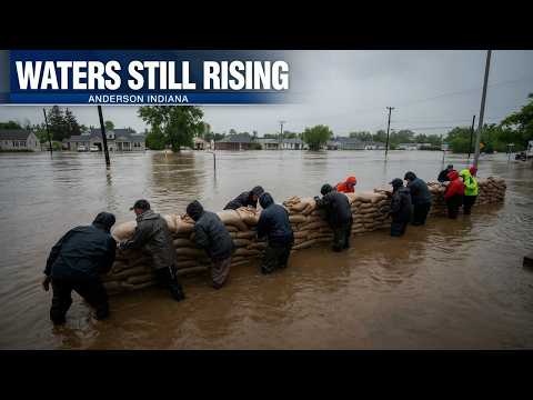
More than 24.9 feet. That is how high the White River stood in Indianapolis, more than a foot above a high-water mark that had held since 1913. 2 In a city built around that river, the number is not abstract. It is living rooms underwater, streets turned to channels, and entire neighborhoods submerged after more than 11 inches of rain fell east of Indianapolis since Tuesday. 2
The water came fast because the storm was violent in almost every way at once. On Aug. 11-12, 2026, a thunderstorm system classified as a derecho moved from Illinois into Indiana, producing extreme straight-line winds, at least two tornadoes, large hail and flash flooding. 4 Indiana emergency management lists it as the August 2026 disaster, a single system with wind, tornado, hail and flood damage compressed into about two days. 4
What followed was a cascade of emergency declarations. Gov. Mike Braun declared a statewide disaster emergency on Thursday, Aug. 13, and deployed the Indiana National Guard. 3 9 Indianapolis Mayor Joe Hogsett separately declared a local disaster emergency, and evacuations began Aug. 14. 7 President Trump approved a Presidential Emergency Declaration for Indiana on Saturday, Aug. 15, after a call with Braun. 8
Water to the rooftops in Henry County
The worst of the early flooding was east of the capital. In Henry County, home to Cambridge City, floodwaters on Aug. 12 nearly rose to rooftops. 5 Broad Ripple residents in northern Indianapolis evacuated with pets as the Indianapolis Fire Department released aerial photos showing whole blocks surrounded by brown water. 6 8 First responders worked around the clock as the river kept rising and neighborhoods that had never flooded began taking water. 6
I saw my fence floating past my window
Frey, a Henry County resident quoted by ABC News, was describing a scene in which yards, fences and first floors disappeared in hours. 5 Her account captures what the river gauge alone cannot: the speed of flash flooding after saturated ground, overwhelmed creeks and more than 11 inches of rain left water with nowhere else to go. 2 5
The human cost grew as the water did. The Associated Press reported at least 5 dead as of Aug. 15. 6 By Aug. 16, the toll had risen to at least 7, reflecting days of storms and record-setting flooding rather than a single incident. 10 Our video for this story aired Aug. 14, before either of those counts was published, so viewers who saw it first saw rescues still underway with no death toll yet established. 6 10
By Aug. 16, there were the first signs of relief. Water began receding in Indianapolis along the White River as rains eased. 10 11 CNN reported that Midwest flooding was beginning to ease even as forecasters warned one more round of storms was on the way for the region. 11 That forecast mattered because saturated soils and crested rivers mean even a smaller storm can restart flooding. 11
Some details in our Aug. 14 broadcast cannot be confirmed from the reporting file assembled afterward. The narration described water standing 2 feet inside at least one home in Cambridge City and inundation in Newcastle and Connersville, but those specific towns and that measurement do not appear anywhere in the provided sources. 5 The broadcast also described night-vision drones and house-to-house checks while water had not receded, and flood watches across eight states. 11 Those drone tactics and the eight-state figure are likewise not confirmed; CNN notes only that one more round of Midwest storms was forecast. 11
That gap does not change the core record. More than 11 inches of rain, a river crest above the 1913 level, statewide and federal emergency declarations, and at least 7 dead make this one of the most destructive Indiana weather events in more than a century. 2 10 Where the broadcast added place names, interior water depths, tactics and multi-state watch counts without a matching source, readers should treat those elements as unverified. 5 11
Known
Unknown
- No verified toll for Newcastle or Connersville, and no verified interior depth or drone-rescue details.
- No confirmed count of states under flood watches at broadcast time.
Next
- Whether receding rivers hold if another round of Midwest storms arrives.
- How state and federal aid reaches evacuated neighborhoods and riverfront blocks.
Sources
11 sources10 outlets1 video
Fort Wayne Journal Gazettejournalgazette.net1
HeyDay News11 video
Indiana Department of Environmental Managementin.gov1
Source map
Follow the evidence behind this report. The map shows its connections; the links below open the sources cited in this article.
Source map loads as you read.
Revision log
- r1First published.