
Conflict · White River floodContinuing story · report 2 of 5
White River Tops 1913 Record as Indiana Floods Kill at Least Seven
The White River topped its 1913 mark by more than a foot after 11 inches of rain, killing at least seven and forcing evacuations from Anderson to Indianapolis.
Transcript · LOADING
Continuing storyDay 1
5 reports22 outlets42 sources5 videos
Full story- No dated events yet
 Update 1Indiana's White River Tops 1913 Record as Floods Force Statewide Emergency
 Update 2White River Tops 1913 Record as Indiana Floods Kill at Least SevenYou are here
 Update 37 Dead as Indiana Declares Disaster Emergency in Historic August FloodNewer
 Update 4Seven Dead as White River Sets Record Crest in Central Indiana FloodsNewer
 Update 57 Dead in Indiana as White River Hits Record Crest After Six Days of StormsNewer
What changed since our last report
10 hours later
Then
Indiana's White River Tops 1913 Record as Floods Force Statewide EmergencyStill open then
- No verified toll for Newcastle or Connersville, and no verified interior depth or drone-rescue details.
- No confirmed count of states under flood watches at broadcast time.
We said we'd watch for
- Whether receding rivers hold if another round of Midwest storms arrives.
- How state and federal aid reaches evacuated neighborhoods and riverfront blocks.
Now
The White River topped its 1913 mark by more than a foot after 11 inches of rain, killing at least seven and forcing evacuations from Anderson to Indianapolis.
Now established
- White River crested at more than 24.9 feet, over a foot above the 1913 record.
- At least seven people had died by Aug. 16 reports.
- National Guard activated and federal emergency declaration approved Aug. 15.
More than 24.9 feet. That is the number that matters most in Indiana right now, a wall of brown water on the White River running over a foot higher than the record set in 1913 3. It is not an abstract high-water mark discussed by hydrologists. It is water over roads, into living rooms, across the bottom of a historic covered bridge, and into the routines of cities that thought they knew where their river stopped.
Indiana's White River broke a flood record dating to 1913 after intense rain that began Tuesday and piled up to more than 11 inches east of Indianapolis 3. CBS News reported the river crested at more than 24.9 feet, over a foot higher than the previous mark 3. In Noblesville, the river broke overnight what local coverage called a 113-year-old record, rising above the bottom of the historic Potter's Bridge 5 6. The old mark is consistently dated to 1913, though labels for its age differ by a year between accounts, so this piece sticks to the year rather than choosing a round number 3 5 6.
The precise crest language matters because nearby numbers sound alike but are not identical in the reporting file. The available web reports give the crest as more than 24.9 feet 3. They do not confirm a separate just-shy-of-25-feet figure as a measured crest, and they provide no population count for flood watches 3. The storm history is likewise narrower than a week-long shorthand suggests. The reporting file traces the heavy rain to Tuesday onward, with more than 11 inches east of Indianapolis since Tuesday, rather than confirming a six-day continuous storm narrative 3.
Death Toll Rose As Waters Peaked
What began as rescues became a rising death toll as the water moved south and reports caught up. On Aug. 15, the Associated Press reported at least five people had died, with first responders pulling people from rising waters along the White River in Indianapolis 2. The same day, ABC cited state officials for at least six dead 11. By Aug. 16, CBS and PBS, drawing on Associated Press updates, put the toll at at least seven dead as floodwaters peaked in Indianapolis early Sunday before beginning to recede 8 9. The sources disagree only in the sense that later reports raised the number, a normal pattern when floods are still moving and counties are still checking.
Government action stacked up city by city and then statewide. Gov. Mike Braun declared a state of emergency, according to CBS 3. Indianapolis Mayor Joe Hogsett declared a state of emergency just before 8 p.m. on Aug. 14 5. Carmel, Fishers and Noblesville also issued states of emergency, and 170 people voluntarily left their homes in Noblesville 6. Braun activated the National Guard, and President Donald Trump approved a Presidential Emergency Declaration for Indiana on Saturday, Aug. 15, after a call with Braun 10. The declarations put state resources on disaster footing while local crews handled evacuations, rescues and sandbag lines.
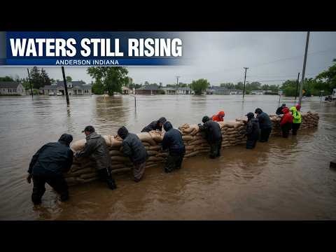
Anderson, east of Indianapolis, showed how fast record water turns an ordinary drive into survival. Record floods forced residents to evacuate there on Aug. 14 4. Resident Anthony Wallace, 55, was driving his roommate's truck looking for a route home when the vehicle was swept into floodwater on Sycamore Street and he spent the morning swimming 4. His account is blunt about the force involved and the lack of warning once wheels lose grip. It is one street, one truck, one morning, but it explains why officials were urging people not to drive through water even where the road looked familiar.
The truck just went 'splash!'
Flooding swamped homes and businesses in Indianapolis as the crest moved through 5. Some riverfront residents in Broad Ripple-area neighborhoods chose to evacuate while others stayed, a split familiar to anyone who has lived near water 5 7. Dan Hall on Edgewater Drive was among those who stayed 5 7. Floodwaters peaked in Indianapolis early Sunday, Aug. 16, with rains expected to ease, offering the first sustained chance for water to fall rather than rise 8 9. That turn does not mean safety. Receding rivers leave weakened banks, contaminated basements, closed roads and currents that remain dangerous after the top number has passed.
The White River system rewards respect for scale. More than 11 inches of rain east of Indianapolis since Tuesday is not a single cloudburst but a saturated basin with nowhere left to store water 3. When the river runs more than a foot above a mark that held since 1913, it is testing levees, bridge clearances, sewer systems and evacuation routes designed around a different idea of worst case 3. Potter's Bridge, a landmark whose timbers have watched generations of high water, took water above its bottom in Noblesville, a visual shorthand for history being rewritten in real time 5 6. Anderson's evacuations on Aug. 14 showed the human side of that abstraction, with neighbors helping neighbors and crews working flooded streets 4.
There is also what the file does not establish, and it matters. It does not provide a verified count of Americans under flood watches on the peak day, so this article does not repeat a population figure 3. It does not provide verbatim quoted text from the governor's declaration beyond the fact of the declaration itself, so this article paraphrases rather than quoting him 3 10. It does not resolve every local crest reading into one statewide number, because rivers crest at different times in different places. Noblesville's overnight break and Indianapolis's early-Sunday peak are separate moments on the same flood wave 5 6 8 9.
Known
Unknown
- No verified population total for flood watches is in the provided sources.
- No verified verbatim quote from the governor is in the provided excerpts.
Next
- Whether Indianapolis-area rivers keep falling as rains ease.
- Whether evacuation zones lift and damage counts clarify in Anderson and Noblesville.
Where
- 1Sycamore Street, Anderson
- 2Potter's Bridge, Noblesville
- 3Edgewater Drive, Indianapolis
- 4Broad Ripple, Indianapolis
- 5White River, Indiana
Sources
11 sources8 outlets1 video
ABC Newsabcnews.com1
HeyDay News11 video
Indianapolis' Public Radio, TV & News Station | WFYIwfyi.org1
Source map
Follow the evidence behind this report. The map shows its connections; the links below open the sources cited in this article.
Source map loads as you read.
Revision log
- r1First published.