
بلایای طبیعی · Oak Creek floodingخبر دنبالهدار · گزارش 3 از 3
Oak Creek’s sharp fall brought only a partial way home for Sedona evacuees
November 2 readings showed a steep retreat, and some residents gained conditional access. But street restrictions and a later SR 89A closure report stop short of a verified November 4 all-clear.
متن پیادهشده · در حال بارگیری
به زبان انگلیسی در دسترس است
خبر دنبالهدارروز 4
3 گزارش40 رسانه67 منبع
کل خبر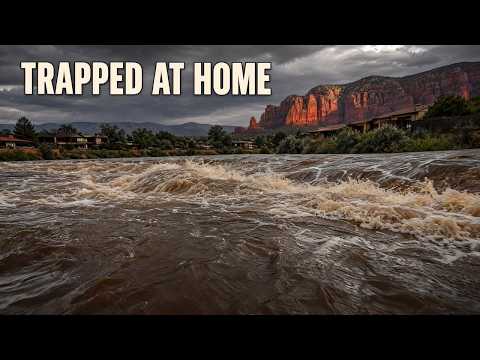


آنچه از گزارش قبلی ما تغییر کرده است
۲ روز بعد
آن زمان
Two highways reopen, but Sedona evacuees still lack an all-clearآنچه گفتیم هنوز روشن نیست
The rescue total, safe road access, current shelter intake status and any subsequent change to the GO order remain unverified.
هنوز روشن نیستWatch for a dated official update addressing the evacuation order, rescue operations, road access and shelter arrangements before treating the emergency as resolved.
هنوز روشن نیست
اکنون
November 2 readings showed a steep retreat, and some residents gained conditional access. But street restrictions and a later SR 89A closure report stop short of a verified November 4 all-clear.
The next chapter of Sedona’s Oak Creek flood emergency was not an all-clear. On November 2, HeyDay News reported that east-side Zones 8, 9 and 10 had been ordered evacuated the previous morning, with residents reportedly trapped in homes and emergency crews responding. Subsequent creek measurements showed a sharp overnight retreat. The access updates that followed described something less complete: conditional returns, streets still closed and a canyon highway that remained restricted.
By November 4, the distinction mattered. The available reports establish substantial improvement after the evacuation emergency, but not a current, unrestricted route home. A November 2 update allowed residents back into most evacuated areas with checkpoints and exceptions; a November 3 report still described State Route 89A as closed for safety. Neither establishes the official status of every evacuation zone or road on November 4. 65 63
A falling creek, two different thresholds
The clearest measurements of the recession came early on November 2, 2026. At Cornville, downstream from Sedona, Oak Creek measured 10.57 feet at 5 a.m. Mountain Standard Time—still 2.57 feet above its local flood stage. At Sedona, the 4:45 a.m. reading was 7.06 feet, below that location’s flood-stage threshold, although the National Weather Service warning continued to describe action-stage conditions there. These are dated observations, not November 4 water levels. 3
واقعیتهای کلیدی
The two gauges need their own danger lines. A height below flood stage in Sedona could not establish that flooding had ended downstream in Cornville. Nor could either reading certify a particular crossing, driveway or bridge as usable.
Our earlier report carried November 1 evening observations of 16.93 feet at Cornville and 12.88 feet at Sedona. Compared with the following morning’s readings, Cornville fell 6.36 feet and Sedona fell 5.82 feet. Those are substantial changes, each measured against the same gauge—not a comparison between the two locations.
They establish that the water receded between observations. They do not establish the exact height or timing of the crest. Our previous account included a forecast of a late-Sunday-night crest at Cornville; a lower Monday-morning reading is not, by itself, confirmation that the forecast unfolded exactly as expected.
The National Weather Service’s morning warning covered Oak Creek in Coconino and Yavapai counties. Issued at 5:39 a.m. MST on November 2, with an assessment timestamped three minutes earlier, it paired falling levels with an unequivocal description of the road danger. 3
Roads are closed and impassable due to flooding. Deadly flooding over low-water crossings.
That warning did not identify every affected road or supply a street-by-street closure list. Its importance was more basic: the creek could be falling while roads remained impassable. A gauge measures water at its location; it cannot tell a driver what floodwater has left behind on the route home.
The warning timeline also moved beyond the morning notice’s scheduled noon expiration. A later notice, preserved by WarningVector and issued at 4:53 p.m. MST on November 2, said the warning would expire at 5 p.m. and described falling levels at both gauges. The available record does not establish the intervening extension from noon. Neither scheduled endpoint establishes whether another warning was in place by November 4. 57
Permission and passage remained separate
For displaced residents, the more consequential change was a qualified opportunity to return. Watch Duty’s update dated November 2 at 4:45 p.m., with no time zone specified, reported that residents could return to most evacuated areas with proof of residency at checkpoints. Blackhawk Lane, Trails End Drive or Lane, and Bear Wallow Lane remained closed. 65
That was a meaningful departure from the initial instruction to leave immediately. It was not a verified, zone-by-zone rescission of GO status for Zones 8, 9 and 10, and it does not establish that the same arrangements continued through November 4. Repeating the original evacuation order as a confirmed current instruction would overstate the record; announcing an unrestricted all-clear would do the same.
Highway access presented a separate obstacle. KTAR reported on November 3 that SR 89A remained closed for safety. AZFamily identified the affected segment as both directions between Sedona and Kachina Village, mileposts 375–397. That is the Oak Creek Canyon corridor, not the entire length of SR 89A. 63 66
No timestamped official transportation notice in the available evidence establishes the highway’s November 4 status or an exact reopening time. The November 3 closure report is useful, dated information—not a live road-status announcement. Likewise, permission to enter an evacuated neighborhood would not itself mean that the highway used to reach it had reopened.
The human outcome of the initial emergency also remains incompletely documented. Sedona Fire District Chief Ed Mezulis had described crews responding to multiple reports of residents trapped in homes. Later reporting by Your Valley and The Guardian repeated the trapped-resident accounts, but did not supply a completed rescue total. The available evidence establishes no verified injury, death or property-damage total; missing totals cannot be translated into a claim that everyone escaped unharmed. 26 1 2
Sedona Red Rock High School was the earlier designated evacuation destination. Its current intake status, operating hours, capacity and a verified safe approach remain unestablished. The return-access update does not answer those shelter questions. 7
For residents, four developments must not be collapsed into one: falling creek levels, a weather warning’s expiration, permission to return and a usable road. The record shows progress on the first and a conditional change on the third. It still does not supply the neighborhood-specific, current clearance needed to treat the journey home as settled.
مطابق پخش ۱۶ خط
- Oak Creek fell more than six feet overnight but still flooded Cornville.
- On November 2, we reported that Sedona had ordered east-side Zones 8, 9 and 10 evacuated the previous morning. Multiple residents were reported trapped in homes, and emergency crews were responding. The later measurements show how far the water subsequently fell.
- Families trying to get home still faced street restrictions and a highway closure after that improvement. How much did falling water actually change their access?
- Cornville sits downstream from Sedona along Oak Creek. The flood warning covered the creek in Coconino and Yavapai counties. Separately, the reported highway restriction ran between Sedona and Kachina Village through Oak Creek Canyon, affecting a specific stretch of State Route 89A.
- Cornville's flood threshold is eight feet. Sedona's is fourteen feet. Each gauge measures conditions at its own location, so the two heights need their own danger lines. A lower reading at Sedona couldn't settle whether flooding had ended downstream, or whether a particular crossing was usable.
- Cornville measured 10.57 feet early on November 2, still 2.57 feet above its eight-foot flood stage. Sedona measured 7.06 feet, below its fourteen-foot flood stage. But the weather warning still described action-stage conditions there, calling for continued attention as the water fell.
- Those are November 2 observations. They describe the recession after the evacuation emergency. At Cornville, water remained above minor flood stage even after a substantial overnight drop. At Sedona, the warning's continued action-stage assessment also gave residents reason to keep watching conditions despite the lower measurement.
- Cornville dropped from 16.93 feet to 10.57 feet overnight, a fall of 6.36 feet. Sedona dropped from 12.88 feet to 7.06 feet, down 5.82 feet. Both changes compare the same gauge on November 1 and November 2.
- Those measured drops show that the creek was receding between observations. They leave the exact crest unresolved. A gauge also can't tell a driver whether floodwater has left debris on a road or whether a driveway or bridge is safe. The morning warning gave a direct description of the danger.
- Floodwater still made roads impassable, and low-water crossings could be deadly. The morning weather warning was scheduled to last until noon on November 2. A later notice that afternoon described falling levels at both gauges and set expiration for five p.m.
- The later notice moved the warning timeline beyond that morning's noon deadline. But a weather warning's scheduled expiration doesn't give residents permission to re-enter an evacuated neighborhood. Local return decisions and road access still have to line up. By that afternoon, some residents did have a qualified way back.
- Residents could reportedly return to most evacuated areas on November 2 with proof of residency at checkpoints. Blackhawk Lane, Trails End Drive or Lane, and Bear Wallow Lane remained closed then. That gave some displaced residents access while keeping restrictions on particular streets.
- Emergency crews had faced multiple calls about residents trapped in homes during the initial flooding. We still don't know how many people were rescued or whether anyone was hurt. The return arrangements described a significant change from the earlier evacuation instructions, but they gave residents only conditional access.
- State Route 89A was still reportedly closed for safety on November 3. The affected stretch ran in both directions between Sedona and Kachina Village, from milepost 375 to milepost 397. That restriction covered the canyon corridor rather than the highway's entire length.
- Sedona Red Rock High School was the earlier designated evacuation destination. Its present operating status is unclear. For November 4, the official return status of each evacuation zone and the highway's reopening status are still unresolved. The dated access changes don't amount to an unrestricted all-clear.
- Officials told people in immediate danger to move to higher ground and call 911 when safe. They also warned residents to avoid washes and creek beds, and never drive through flooded roads.
منابع
67 منبع40 رسانه1 متن خبرگزاری
AZ Familyazfamily.com4
KTAR.comktar.com4
National Weather Serviceweather.gov4
- نخستین گزارش
- Flood Warning issued November 2 at 5:39AM MST until November 2 at 12:00PM MST by NWS Flagstaff AZ
- Flood Warning issued November 1 at 8:35PM MST until November 2 at 12:00PM MST by NWS Flagstaff AZ
- WWA Summary for Flood Warning
- WWA Summary by Location for 34.31N 111.95W with AZZ037/AZC025/AZZ137 emphasis Flood Watch
forth.news3
- Flash Flood Warning issued November 1 at 8:15AM MST until November 1 at 11:15AM MST by NWS Flagstaff AZ | National Weather Service | Forth
- Evacuation Immediate Alert from AZCoconinoCountyDepartmentofEmergencyManagement | Emergency Alerts | Forth
- FLOOD WARNING REMAINS IN EFFECT UNTIL NOON MST TODAY | National Weather Service | Forth
ABC15 Arizona in Phoenix (KNXV)abc15.com2
ArcGIS StoryMapsarcgis.com2
KNAU Arizona Public Radioknau.org2نخستین
Arizona Daily Sunazdailysun.com1
Arizona Expressarizona-express.com1
az511.com1
Colorado Springs Gazettegazette.com1
floodriskhere.com1
FOX 10 Phoenixfox10phoenix.com1
Jacksonville Journal-Couriermyjournalcourier.com1
KGUN 9 Tucson Newskgun9.com1
KVOAkvoa.com1
Nivelmapnivelmap.com1
- نخستین گزارش
- Oak Creek near Sedona: Gage Height Now
roadconditions.com1
Rolling Outrollingout.com1
Sedona Red Rock Newsredrocknews.com1
- نخستین گزارش
- Sedona urges evacuation of areas along Oak Creek
Sedona.Biz - The Voice of Sedona and The Verde Valleysedona.biz1
Storm Station 247stormstation247.com1
Telemundo Phoenix/Tucsontelemundoarizona.com1
The Guardiantheguardian.com1
Visit Sedonavisitsedona.com1
Warning Vectorwarningvector.com1
- نخستین گزارش
- Flood Warning
Watch Dutywatchduty.org1
WHEC.comwhec.com1
Your Valleyyourvalley.net1
نقشه منابع
شواهد پشت این گزارش را دنبال کنید. نقشه ارتباطهای آن را نشان میدهد؛ پیوندهای زیر منابع استنادشده در این مقاله را باز میکنند.
نقشه منابع هنگام مطالعه بارگیری میشود.
سابقه بازنگری
- r1نخستین انتشار.